Little Solsbury Hill Circular (Bathscape Walk 9)

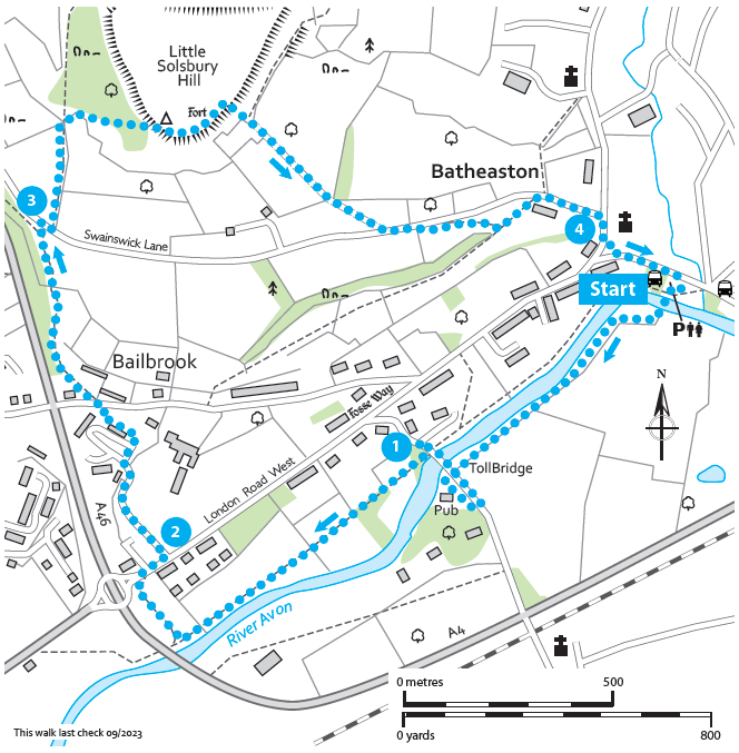
Starting and finishing on Batheaston High Street this circular route starts with gentle riverside views before climbing up to the top of Little Solsbury Hill and returning via the shops and cafe of Batheaston.

Distance

3.25 miles / 5.23 km

Duration

1.5 to 2.5 hours

Difficulty

May be steep slopes, moderate fitness

Shape

Circular

Route description

The top is 191m (625 feet) high and has been owned and managed by the National Trust since 1930. The sides are owned and managed by Batheaston Freeholders Association. The two organisations work together very closely to look after the site as a whole. Little Solsbury Hill was occupied as a hill fort during the early Iron Age. Archaeological remains suggest people lived here between 500 to 100BC. There would’ve been about 30 buildings made from timber, wattle and daub. In more recent history, there is evidence of medieval field systems on the hill top, and the summit was still being used for agriculture well into the 19th century.

Mostly unimproved limestone grassland, in the spring and summer, it is covered in wildflowers, including early purple & pyramidal orchids. Keep your ears open for the remarkable song of the skylark, a groundnesting bird which breeds here (so please keep dogs to the main paths).

The hill was also the inspiration for Peter Gabriel’s song “Solsbury Hill”.

Best avoided in the winter or after prolonged periods of wet weather as the slope below the trig point is very muddy and slippery.

Start

Address

1, 217 London Rd E, Batheaston, Bath BA1 7NB, UK
View start on Google Maps

OS Grid Ref

ST779674

What3Words

pepper.fills.bleak

Public toilets

At the start (charged)

Refreshments

Shops and Cafes of Batheaston and The Bathampton Mill Pub

Travel Info

Visit travelinesw.com. Bus Stop next to start point on London Road East. Car park free but restricted to 2 hours. Free parking available elsewhere in the village. Please park respectfully.

Navigation

From the Batheaston Riverside and Gardens car park, cross the river via the bridge which ends in a footpath. Follow this along the river, when it curves sharply to the left, take the right fork to cross a small wooden bridge, keeping an eye out for Batheaston Watermill information board.

Pass under the road and then bear left into the car park of the Bathampton Mill Pub. Turn left at the car park entrance onto Mill Lane. Turn left again to walk along the pavement of the road and across the toll bridge (free to
pedestrians).

1 Once on the other side, take a sharp right towards The Old Mill Hotel and the road “The Willowfalls” and look for a tunnel under the bridge on your right. Go through the tunnel to pass under the toll bridge. You should have a fantastic view of the weir on you left. Follow the footpath along the river to a metal gate. Go through the gate and continue straight passing along the back of some gardens, along the path next to the archery range and then onto some rugby pitches. Keeping the river on your left walk the length of the pitches until the footpath enters a small wooded area.

Soon you will pop out onto a shared use path. Look out for cyclists as you turn right and follow the path up hill to meet London Road West.

Use the pedestrian crossing to cross over to the far side of the road, then turn right. Take the first left up Eveleigh Avenue 2. Follow the pavement up hill and then take the left turn, staying on Eveleigh Ave (rather than continuing on to the hotel).

As the road curves round to the right follow it round. Soon you will see a short flight of steps in front of you. Go up the steps and follow the tarmac path up and round to the left until it pops out on Bailbrook Lane.

Look to your right and you will see a tin church a little further up the road. You may wish to take a closer look before retracing your footsteps back to continue.

Turn left and look for the track that runs along the back of the houses, to the right of number 35. You will pass a post box in the wall on your right. Walk along the track which then narrows to a footpath along a garden fence. Continue straight ahead onto a stone path which heads up hill. You should be able to hear the A46 to your left. Follow the tree lined path all the way up and then down a couple of short sets of steps. Shortly after these look out for a marker post at a fork. Take the right-hand turn up a path which ends on Swainswick Lane 3. Carefully turn right onto Swainswick Lane and soon after turn left to take the sign posted public footpath on your left into a field, through a gate.

Keeping the hedge line on your right, walk along the edge of the field until you meet a wooden gate at the foot of Little Solsbury Hill. Don’t forget to look behind you for the views of Bath.

Once through the gate, take the steep path ahead, ignoring the footpath to the left, up to the summit of Little Solsbury Hill. Please take care after wet weather here as it can be very muddy and it is easy to fall. This part is the worst, once round the corner the path continues to dry as you climb higher. Soon you will see the trig point.

Catch your breath at the trig point and enjoy the views. When you are ready to start making your way back, with your back to the view, turn right  and follow the edge of the hill, which was once the site of an iron Age Hill Fort, until you see the back of a National Trust sign.

Turn right here down hill towards a gate. Pass through the gate and follow the lane all the way down hill to a T-junction. At the T junction turn left, continuing down hill until you see a footpath on your right.

Take the footpath across a field to a metal gate. Go through the gate from here the public right of way is diagonally across the field to a metal gate. However, in the summer months it may be easier to go round the edge of the field, following the left field boundary downhill, then turning right, following the hedge to, and then through a metal gate. Turn left after the gate and walk across another field before descending some steps and turning right back into the lane. Take care walking in the narrow lane.

At the T-junction turn right, continuing downhill. Pass the Church of the Good Shepherd on your left and as the road bends to the right take the flight of steps straight ahead 4.

At the bottom turn left onto Batheaston High Street. Use the crossing to cross the road, then turn right and after a short distance left into the car park.