Tetbury circular via Ashley (Cotswold Gateway)

This walk begins from the public car park at Tetbury Goods Shed Arts Centre at the bottom of Chipping Street.

Distance

6.5 miles / 10.46 km

Duration

3 to 3.5 hours

Difficulty

Unsurfaced paths, basic fitness

Shape

Circular

Route description

The walk follows the route of the old railway line which is accessed at the far end of the car park away from the Shed.

Start

Address

33 Gumstool Hill, Tetbury GL8 8DG, UK
View start on Google Maps

OS Grid Ref

ST894933

What3Words

fabricate.subsets.streetcar

Public toilets

Disabled toilets at Warn’s Court car park off West Street.

Refreshments

Several hotels, pubs and cafes.

Travel Info

Tetbury is on the A433 10 miles SW of Cirencester and 23 miles NE of Bath. Approaching from Cirencester turn left before the town, at a sign for Tetbury industrial estate and take the road downhill for half a mile. The Old Railway Yard free car park is on the left at the bottom of the hill. From the town centre, opposite the Market House take Chipping Lane downhill and turn right into the car park.

Navigation

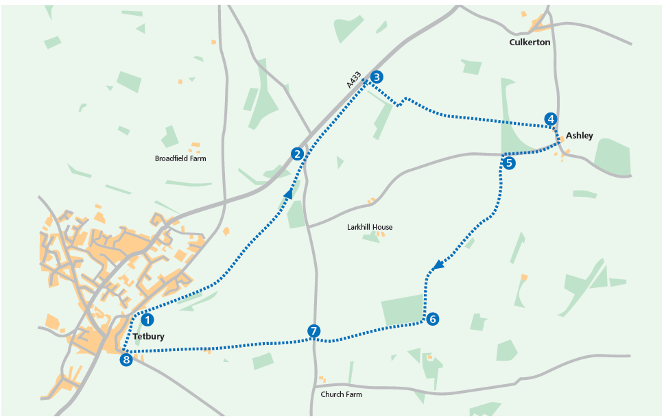
This walk begins from the public car park by the Tetbury Goods Shed at the bottom of Chipping Street. It follows the route of the old railway line which begins at the far end of the car park away from the Shed (1). For some distance, this path has a good all weather surface and takes you along a sheltered tree-lined valley. You do not deviate from this path at any point, going straight through any stiles
or gates.

After about thirty minutes, you will become aware of the increasing volume of traffic on your left. The path rises left a little to a gate. Go through the gate and over the road (Newnton Hill) (2). Turn slightly right, down a cinder track towards the trees, to continue in the same direction as before.

Follow this for around 15 minutes until, once again, you come closer to the main road on your left. Your way ahead is barred by a gate. Turn right, over a stile and into a field (3). Follow the slope uphill, keeping the trees on your left. Go into the next field, keeping the hedgerow on your left. Just before the end of this field, go through a gap on the left. The hedgerow is now on your right and a barn is visible in the middle distance.

After the barn, the track surface improves and your route follows a line of recently planted trees on your left. Follow the track for half a mile. Ahead of you, at 11 o’clock, you can see the Cotswold Airport.

Go through a gate and continue until you reach a road (4). Turn right into the village of Ashley and go past a duck pond. Walk a short distance before turning right along the lane signposted Long Newnton and Tetbury.

At this point, you may wish to continue a short way along the lane into the village until you reach the attractive 12th century church of St James. Once you have visited it, retrace your steps to the junction and turn left.

You will pass a house and pond on your left. Continue until you reach a gate on your left and a signpost for a public footpath and the ‘Monarch’s Way’ (5). Follow this long distance footpath all the way back to Tetbury.

Walk over two fields with the hedgerow on your immediate left. Go through a gap in the wall, then follow a broad path through the middle of a third field towards a line of trees. When the path bends to the right, turn off it. Go straight ahead through a gap in the trees. Turn a little left and, keeping the hedgerow on your left, walk towards a woodland ahead.

Turn left between the hedgerow and the woodland into another field. Follow the edge of the field with the wood on your right, through another gap, into a further field. Keeping the woodland on your right, continue on. When you get to the corner of this woodland, there is a crossroads. Turn right keeping the same woodland to the right (6).

The woodland ends, to be replaced by a hedge. Where this ends, go through to the next field, past the brick pillbox on your left, with the hedgerow now on your left. Stay on the track until you reach a gate and road (7).

Go through the gate, across the road, bearing left towards a kissing gate in the hedgerow, signposted the Monarch’s Way.

Once through the gate, continue with the hedgerow on your right. When the hedgerow disappears , continue along the same line. Walk around the corner of the field to a stile in the hedge. Over the stile, your route lies straight across the middle of the next field towards the bottom right hand corner, aiming directly at the spire of Tetbury’s Church, St Mary the Virgin, in the distance.

Going through a gate, continue across the field towards the farm. Go between the farm buildings on to a concrete track. Stay on the concrete, until you can go no further. Here a stone stile and kissing gate on your right takes you on to another track. Follow this all the way and down some steps, to emerge on to the B4014 with the town on your right.

Turn right and walk down the pavement to the signpost for the Tetbury Trail (8). Turn right and follow this track back to the Goods Shed and car park.