Thames Path & the Source of the River Thames (Cirencester Ramblers Walks around Cirencester 6)

A circular walk taking in the source of the River Thames, disused canal and railway heritage as well as undulating countryside.

Distance

9.5 miles / 15.29 km

Duration

2 to 3 hours

Difficulty

Uneven, steep slopes, good fitness

Shape

Circular

Start

Address

5 Market Pl, Cirencester GL7 2NX, UK
View start on Google Maps

OS Grid Ref

SP023020

What3Words

land.prom.hiring

Public toilets

The Forum car park.

Refreshments

Pubs and cafes in Cirencester.

Travel Info

Parking in the Market Place, Waterloo or the Forum car parks (charges apply). Buses from numerous places see https://www.travelinesw.com/ for details.

Navigation

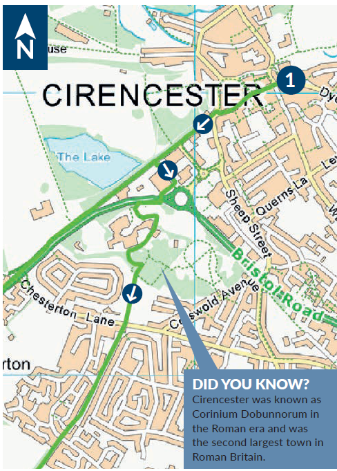
❶ From the Church porch turn right along Castle Street. At the end of street continue in the same direction following pavement by high stone wall. Cross the road at Cotswold Leisure Centre and walk down left side of the building past main entrance. At the road take path over footbridge. Continue to bus stop; turn left, then left again through hospital car park. At service road turn left; at junction turn right and follow pavement round the hospital. Opposite the main entrance to the building turn left through small car park to path by the Roman sarcophagus. Follow path through the woods to T junction; turn right up slope and continue on into the Four Acre Playing Field.

❷ Continue in same direction to a gate at top right of playing field. Cross the road almost opposite and take long straight tarmac path running along backs of houses. Cross a road and continue in same direction. Go through a gateway and pass farm buildings. At end of track turn right and almost immediately left to follow field edge by wall. Continue through a hedge, following the wall to a second hedge. Pass thorough this hedge and turn left following field edge to a gate. Go through gate and turn right onto track. At next junction turn left onto a wider track. Follow this past farm buildings, crossing disused railway and canal bridges. Join the public road and continue in the same direction. At a cottage on the left take bridleway on the left. At end of path turn right onto the road.

❸ Follow the road through Ewen village, continuing in same direction to end of village, then take path on the left. Follow this with river channel on your left. Cross a road and continue to follow the clear path with the channel on your left. At a gate cross the road (please be aware of traffic). Cross a gate into next field and take path on right across a small bridge. Follow line of river and then cross field to pedestrian gates on the left. Cross the farm track and continue in same direction. Follow field boundary on your left until you reach a waymark post. Take right hand path and cross field to a gate in the distance. Cross the road (take care: fast, busy road). Continue in same direction through two gates following a track. Pass next gate and follow track towards stone marking the Source of River Thames.

❹ Continue in same direction through two gates following a track. Pass next gate and follow track towards stone marking the Source of River Thames. Continue in same direction following field boundary on right. Cross three stiles and follow a track up and over canal bridge. After the bridge turn right onto footpath. Cross stile into field and follow field boundary on your right, to stile in field corner. Cross lane and continue in same direction on the Monarch’s Way with wall on your right. At end turn left and right and continue in same direction through field with boundary on your right. Pass through a gate and a gap, then following the boundary, bear left to join a track. Turn right and follow track past farm buildings, down
a slope and straight on past a wood. Continue in same direction, following a track and then a path. Enter Royal Agricultural University playing field and continue straight on, cross the main drive and pass the changing rooms. Follow tarmac path and where this turns off continue straight on following hedge on your left. Continue to follow the hedge; bearing right, follow this to the road. Go through gate and turn left to follow narrow pavement. Cross roundabout and follow pavement around to the left. At high stone wall turn right and continue down hill, with wall on left, back into town. Where the wall turns left take road on the right, Castle Street, and follow this back to the Church.