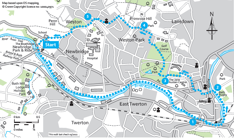
West of Bath Circular (Bathscape Walk 5)

A mostly flat route along the River Avon tow path into the city centre.

Distance

7 miles / 11.27 km

Duration

3.5 to 4.5 hours

Difficulty

May be steep slopes, moderate fitness

Shape

Circular

Route description

Passes the famous Royal Crescent and goes through Royal Victoria Park before a long climb on the return leg up to rewarding views over Bath.

This could be walked as two shorter linear routes from the Park and Ride into Bath and then getting the bus back, and vice versa, using the bus to get into Bath and then walking back.

Start

Address

Newbridge Park & Ride, Bath BA1 3NB, UK
View start on Google Maps

OS Grid Ref

ST718657

What3Words

rush.orchestra.rent

Public toilets

Newbridge Park & Ride, on Southgate Street in the city centre, Charlotte Street Car Park in the city centre (charges apply)

Refreshments

The Boathouse Pub next to Newbridge Park & Ride, Basil’s Bakery at Locksbrook, numerous city centre options.

Travel Info

Visit travelinesw.com for bus information to and from Newbridge Park & Ride. Free car parking available at Newbridge Park & Ride.

Navigation

From Newbridge Park & Ride bus stop, pass through the car park behind the building which contains the toilets.

At the far end take the footpath next to the gate which leads to the rowing club (easily identifiable by the oars fixed to the gate). Once on the other side turn left and follow the footpath down and round to the Boathouse Pub car park. Here you should be able to follow Circuit of Bath* way markers through the car park and then under the bridge via a low arch. On the other side of the arch, you will be on the River Avon Trail.

Follow the tow path over a footbridge where you can enjoy views of the marina below to your left. Then just follow the tow path for approx. 2.5 miles. In Summer 2022 there was a long-term diversion at Windsor Bridge Road, follow the Diversion signs. Along the way you will pass a set of locks, a couple of green spaces and pass under several bridges. Keep an eye out for swans, cormorants and other waterfowl along the way.

When you reach the city centre the tow path comes up to join the pavement of the A367 1.

Continue straight ahead and use the zebra crossings to cross the busy road at the mouth of the bridge. Further ahead you will see a pedestrian bridge parallel to the one you have just passed.

Turn right to cross the bridge. When you are on the other side of the river turn left and take the short flight of steps down onto the tow path. Now the river will be on your left. Keep following this along, under two bridges until the path forks. As you pass under the second bridge note the flood marks carved into the stone work. Take the right-hand fork, slightly uphill away from the river. At the top turn left crossing over the canal with a set of locks on your right.

You will be back on the tow path now, with the River Avon on your left. Continue to follow the path under the railway bridge until you pass Parade Gardens on your left (on the far side of the river) and Bath Rugby stadium on your right. Ahead will be the weir and a pleasing view of Pulteney Bridge which you will later walk over.

A short while on you will pass the Beazer Garden Maze which is a fun diversion, now bearing left head on to a flight of steps which take you through the café’s outdoor seating up onto Pulteney Bridge 2. Turn left to cross the bridge, continue onto Bridge Street and bear slightly right to walk along Upper Borough Walks. At this point you can divert left to visit Bath Abbey.

To continue, turn right onto Burton Street. You are now walking along the Cotswold Way National Trail. Turn left along Quiet Street then Wood Street to Queen Square. Turn right to keep the square on your left as you start to walk uphill. Cross at the pedestrian lights and continue to walk uphill along Gay Street, passing the Jane Austen Centre on your right.

At the top you will reach The Circus turn left and follow it round a quarter then turn left down Brock Street. Before you reach the Royal Crescent view point, turn left (though a quick diversion to the view point is worth it).

Head down the slope and then turn right where the path crosses so you have views of the Royal Crescent on your right as you walk its length. At the road at the end turn left, then cross the road carefully to turn right to pass into Royal Victoria Park 3, passing the Victoria Monument.

Shortly after the monument the road continues straight or curves sharply round to the right and uphill. Follow this right turn, continuing on the Cotswold Way until you exit the park onto a road.

Cross the road at the zebra crossing and then continue on the Cotswold Way uphill along the tree lined tarmac path through the green open space (formerly a golf course).

At the top, turn left, and follow Sion Hill round the corner and then steeply uphill. At the T-junction turn left. Follow Summerhill Road to the end where straight ahead there is an alleyway next to a bus stop and a Cotswold Way finger post. Follow this as you start to descend down a flight of steps. Cross a road 4 and continue down another alleyway passing through a gate and onto a footpath between hedges.

Continue on this path as it widens, ignoring the option to divert left. Follow the Cotswold Way waymarkers up to a gate, go through the gate into the field beyond. Soon after the path splits, take the lefthand fork, staying on the Cotswold Way. Follow the path through the meadow to a gate in the bottom left hand corner of the field. Go through the gate to start your descent.

Follow the Cotswold Way all the way down, crossing Purlewent Drive until you see a gap in the wall of the churchyard of All Saints Church. Cut through the tranquil space, passing in front of the church and then down the footpath ahead down towards Weston village. Continue on the pavement which runs slightly above and parallel to the High Street until you meet Trafalgar Road 5.

Cross Trafalgar Road, when you reach the zebra crossing turn left to cross Crown Road and walk up Penn Hill Road until you see a gate on your right. Take the gate into the playing fields. Here the Cotswold Way diverts diagonally across the fields. You will start to follow Circuit of Bath way markers from here back to the start.

Walk across the field, parallel to the road until you exit back onto the road through the second gate. Carefully cross the road and turn right. Walk along the pavement, crossing several small residential streets. After you have crossed Meadow Gardens, cross the road at the next crossing point. Turn left and take the minor road ahead. Continue straight as the road becomes a path. Follow it as it passes between the modern and old parts of Oldfield School until Kelston Road.

Use the pedestrian crossing to cross to the pavement opposite, turn right and walk along the pavement until you reach a gate on your left. Go through the gate into Newbridge Slopes Local Wildlife Site. Follow the path down through the woods until it emerges into a meadow. Follow the path and Circuit of Bath way markers back to the start.

*The Circuit of Bath is a 20.5 mile circular route around the Bathscape. It can be walked in sections or in one go, and guides like this one are available to download to accompany each leg.