Winchcombe to Belas Knap Long Barrow (Cotswold Gateway Winchcombe Walk 5) - Circular Walk

Heading out from Winchcombe along the Cotswold Way to Belas Knap before returning via the Sudeley Valley. Lovely views of the town, Sudeley Castle and the surrounding countryside.

Distance

5.5 miles / 8.85 km

Duration

2 to 2.75 hours

Difficulty

May be steep slopes, moderate fitness

Shape

Circular

Route description

This route has been delivered in partnership with Winchcombe Welcomes Walkers www.winchcombewelcomeswalkers.com

Start

Address

Back Lane Car Park
View start on Google Maps

OS Grid Ref

SP025285

What3Words

surprise.insist.automatic

Public toilets

Back Lane car park near the library.

Refreshments

Various places in the village.

Travel Info

Back Lane car-park (charges apply) behind the library.

Navigation

Leave Back Lane car park via the far corner access into Cowl Lane. Turn right and follow the road to the High Street. Turn right and walk along Abbey Terrace until you are opposite Vineyard Street.

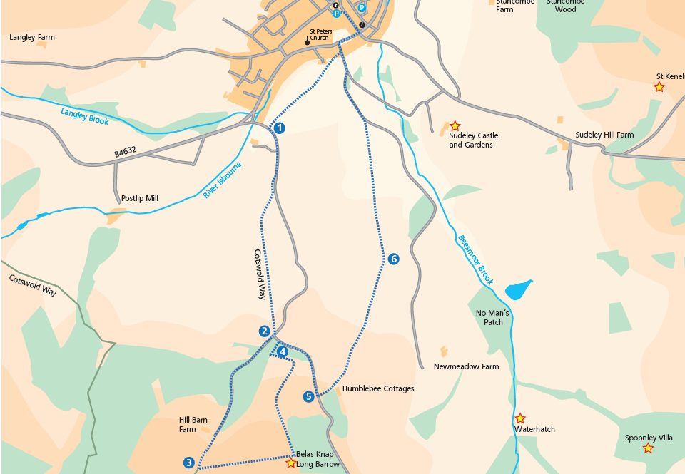
Carefully cross the road and continue down Vineyard Street, cross the bridge and shortly turn right through a gate waymarked the Cotswold Way. Follow the Cotswold Way straight across the field to another gate and continue for approx 450 metres until you reach a road, Corndean Lane (1). Turn left along the road for 300 metres and turn right through a gate waymarked Cotswold Way.

Follow the tarmac drive as it rises past the cricket pitch. Shortly after a horse dressage training area, go through the gate on your left and follow the Cotswold Way up the hill, noting the fine views back towards Winchcombe and beyond.

At the top of the field, pass through the gate and go down a short ramp to a T junction of minor roads (2). Here you can take a slightly shorter route to Belas Knap. See ‘Cotswold Way route to Belas Knap’ at end of the route description.

Turn right along the lane, noticing the good view over the Isbourne valley to the hills north-west of Winchcombe. After approx 350 metres at a Y-junction of lanes, turn left and climb steadily along the lane through woods. You may be lucky enough to see deer lurking in the trees. The buildings of Hill Barn Farm come into view at the top of the lane. Carry on in the same direction past the farm along a gravel track for 300 metres then turn left to join the Cotswold Way (3).

Looking forward, you will see the smooth form of Belas Knap, an ancient long barrow.

Go over the low stone wall and through a gate on the left, follow the Cotswold Way beside a stone wall to another gate. Go through and descend to the bottom where the path turns left to follow the field boundary beside a wood. (The right of way path follows the edges of the field: it does not cut diagonally across). Upon reaching a gate go through and descend on a sunken path through woods to a gate leading onto the road, signposted Winchcombe Way (4).

Turn right along the narrow road for approx 500 metres being careful of traffic. Ignore a path on the left before the top of the rise and continue to meet a track on the left waymarked Winchcombe Way (5).

Turn left down the gravel track, pass some cottages and bear left down the slope following the Winchcombe Way signs. Ignore the path leading right just after the cottages.

Continue down the track, passing to the right of Wadfield Farm, and join the narrow path between hedges to a stile entering a field F. There is a good view here towards Sudeley Castle and St Mary’s Church. Go diagonally across the field to a stile on your right in the hedge, go over the stile and enter the next field.

Turn left along the edge of the field for 100 metres and enter the next field. The path goes diagonally across this field to a footbridge, continue diagonally across the second field to a gate. Go through and continue across the third field to join a lane. Turn left along the lane (the Old Brockhampton Road) and follow this until you reach the entrance to Sudeley Castle.

Keep left and follow the lane, (Vineyard Street) over the bridge and up the slope to Abbey Terrace.