Coaley Peak to Selsley Common – Walking with Wheels

A waymarked accessible scenic woodland route roughly following the Cotswold Way, joining the two Commons.

Distance

6 miles / 9.66 km

Duration

3 hours

Difficulty

Unsurfaced paths, basic fitness

Mobility aid rating

Stile free

Shape

Circular

Route description

This trail runs from Coaley Peak and the Nympsfield Long Barrow to visit “The Toots” Long Barrow on Selsley Common. Both areas are rich habitats.

This undulating mainly woodland trail uses the Cotswold Way where accessible with wheels, and permissive paths where it is not. The woodland is carpeted with wild flowers in springtime with open views over the Severn Vale to the Malverns.  Leafy and shady in summertime but more restricted views. Can be muddy on the lower-lying sections. Two Radar Gates so key is essential for scooter riders to use this route. One two-way gate to enter Selsley Common.

Coaley Peak was farmed for arable crops for many years before Gloucestershire County Council reached a decision to turn it into a picnic site that would make the most of its fine views. Coaley Peak was adopted by GWT in 2016 and has been managed as a nature reserve since then.

Nympsfield Long Barrow Excavations were carried out by Professor Buckman in 1862, Mrs Clifford in 1937 and in 1974

Selsley Common has superb views over the River Severn and Malvern Hills into Wales. Its internationally significant grassland is home to a breathtaking array of wildflowers, birds and invertebrates and is designated a Site of Special Scientific Interest.

Some of the Selsley Common stone was quarried and used to build walls and make lime. Large blocks were used to build nearby Woodchester Mansion.

The rare, unimproved grassland there has produced a very special ecosystem. The soils are thin and low in nutrients, so only specialised plants can survive here. You will find wild herbs and flowers like Rock Rose, Birds’ Foot Trefoil, Wild Thyme, Scabacious, Harebell and Blue Milkwort. Several rare wild orchids thrive here, including Bee, Pyramidal, Common and Green Winged.

Selsley Common is home to ground nesting birds like skylarks and meadow pipits. Skylarks are classified as ‘red’ on the British Birds of Conservation Concern list which means that their population is in steep decline. In the UK, the population halved during the 1990s and continues to decline.

Coaley Peak has ample free parking and a picnic area but no toilets or refreshments. National Trust Woodchester Park is a short drive away and offers accessible toilets and refreshments.

(NT Woodchester Park, Tinkley Gate SO8139 0081 ///name.explorer.propelled).

Café and toilets also at the Gliding Club ///reference.ignoring.mincing (limited opening Thursday to Sunday).

Bristol and Gloucestershire GC moved to Nympsfield in 1957, and one of the founders was naturalist Sir Peter Scott, who went on to become British Gliding Champion.

For more information about Coaley Peak see website  https://www.gloucestershirewildlifetrust.co.uk/nature-reserves/coaley-peak

Selsley Common is a SSSI managed by Stroud District Council and also hosts a Long Barrow. Another rich habitat well described here

https://www.uksouthwest.net/gloucestershire/selsley-common/

Start

Address

Coaley Peak
View start on Google Maps

OS Grid Ref

SO 79448 01222

What3Words

///rags.export.irritated

Public toilets

Toilets at the Gliding Club ///reference.ignoring.mincing and NT Woodchester Park (Tinkley Gate ///flush.toffee.wooden).

Refreshments

Café at the Gliding Club ///reference.ignoring.mincing and at NT Woodchester Park (Tinkley Gate ///flush.toffee.wooden).

Travel Info

Public car park to west side of B4066 - no charge, no facilities, picnic tables. GCC Robin calls here. This is a bookable bus service. It is recommended to book a few days in advance. 0345 2638139 or online. Nearest public bus stop Bristol & Glos Gliding Club or Nympsfield.

Navigation

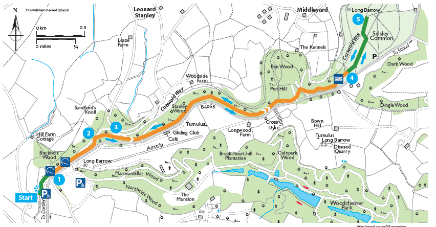
This is a waymarked linear route with options at both ends to explore the Commons. Start at the Picnic area at Coaley Peak (1), join the Cotswold Way north past the Nympsfield Long Barrow then bear right through woodland and pass through a RADAR gate and continue with a fence on the left. In a short while leave the Cotswold Way (2) to bear right towards the road and pass through a second RADAR gate turning back into woodland up a short steep bank to follow the permissive bridleway until it rejoins the Cotswold Way (3).

After 150 m (4) leave the Cotswold Way once more and follow the permissive bridleway past the Gliding Club and into Pen Wood, crossing a tarmac driveway, then continuing (shortly crossing a second tarmac driveway) to reach Selsley Common via a two-way gate (5). A second Long Barrow (The Toots) lies on the Cotswold Way ahead (6).

After exploring the Common return by the same route.

Video of the route.

Route media