Kingham Station Short Circular - Car Free

This is the first in a new series of car free walks from the Cotswolds National Landscape designed to allow people to use public transport to arrive at their starting point.

Distance

3.5 miles / 5.63 km

Duration

2 to 3 hours

Difficulty

Unsurfaced paths, basic fitness

Shape

Circular

Start

Address

Rail Station turn, Chipping Norton OX7 6SX, UK
View start on Google Maps

OS Grid Ref

SP256227

What3Words

readers.assures.betraying

Public toilets

Kingham Station (not accessible)

Refreshments

Kings Head Inn in Bledington

Travel Info

Kingham Station. Buses: X8 Kingham Station Bus rail-link. Trains: Rail enquiries 08457 484950

Navigation

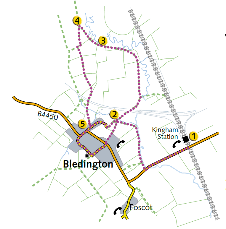
1 From the station turn right down the road. At this point you cross the county boundary, from Oxfordshire into Gloucestershire. At the small bridge turn right down a narrow footpath and make your way along the River Evenlode, over a stile and into a field. Walk along the hedgerow, noticing the ridge and furrow features in the field to your left. Climb over a stile, keeping the river on your right and make your way across two fields. Keep to the footpath around the edge of the field, across to the fenced water treatment works. Notice that the hedge on the right is largely blackthorn (sloe berries for sloe gin). Walk down the side of the water treatment works along the field edge, and turn right over the footbridge.

2 Turn right and cross the field to a stile. (To make a short walk into Bledington go to the top right field corner and follow the lane to route point 5.)

Cross the disused railway track bed, notice the construction of the embankment. Go into the next field and follow the hedge on your left. This has recently been laid, (the process traditionally used to maintain and manage hedges to keep a stock-proof barrier). Continue ahead over a stile following the hedge. Cross the stile or gate, noting the traditional pollarded willows. Follow the hedgerow around to the left to the gate by the river.

3 Go through the gate and follow the field edge around past the pond. This is a very wet, boggy area, to avoid this turn right and follow the rivers edge across the field. Continue past the pond to the fenced gap in the hedge, go through the gap keeping the river on your right follow the field edge to another fenced gap and again cross to a stile in the far corner by the woods. Notice evidence of old hedgelaying here with thick interwoven stems at the base and newer growth on top.

4 Turn left down the track. After 20 meters the path bends to the right, turn left through a gateway in a woody hedge. Cross two fields to a stile at the top of this small hill. Continue ahead with views of Bledington below. After the gate bear right down hill. Cross the disused railway track bed again and notice the construction of the embankment. Continue across the field and cross the small stone bridge, bear half left towards the houses between the farm buildings. Cross the stream bridge and follow the path to the lane.

5 Turn right along the lane, passing the village shop to Bledington Green and the Kings Head. Turn up Church Street off the green to the church. Bear left around to the road. Take the path opposite and follow down, crossing the field back to the footbridge over the Evenlode River that you crossed earlier. Turn right and retrace your steps along the riverside passing the ridge and furrow patterns again, to the road and station.