Leckhampton Hill mobility scooter route

A fairly short route around Leckhampton Hill, with lovely views on a clear day. Route is suitable for all-terrain mobility scooters. Route video for pre-assessment available below.

Distance

2.25 miles / 3.62 km

Duration

1 to 2 hours

Difficulty

Unsurfaced paths, basic fitness

Mobility aid rating

Pushchair friendly

Shape

Circular

Route description

This route is suitable for all-terrain mobility scooters, and offers easy access to fine views over the Severn Vale, and passes through historic and ecologically rich terrain. It was designed and executed by the Cotswold Voluntary Wardens as a 50th Anniversary project with the help and support of the Leckhampton Hill Ranger (Cheltenham Borough Council), Friends of Leckhampton Hill and Charlton Kings Common and the Disabled Ramblers.

Start

Address

Brownstones Quarry Car Park
View start on Google Maps

OS Grid Ref

SO951179

What3Words

scarf.abstracts.zoomed

Refreshments

Star Bistro (Mon-Fri) Ullenwood GL53 9QU or the Wildlife Trust Café at Crickley Hill with accessible toilets.

Travel Info

Brownstone quarry Car Park, Hartley Lane, Leckhampton.

Navigation

This route is a mix of hard or grassy and mostly flat surface accessible by any reasonably sturdy mobility scooter. Can be muddy after rain. Gradients do not exceed 10% and there are no significant cross gradients. There are gates along the way but these are fixed in an open position unless livestock are grazing the hilltop.

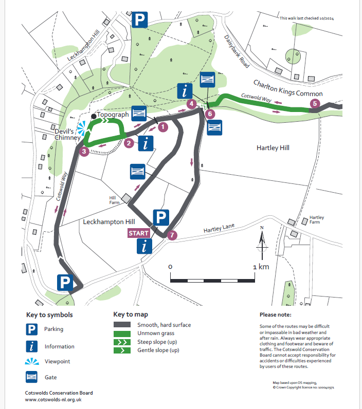
Start from the Brownstone car park in Hartley Lane. Access from Leckhampton Hill Road or the A435, Seven Springs roundabout. From the car park turn right and take the track past the barn, continue through a gateway onto a tarmac path to meet a cross path at 1. Turn left and shortly go through a gate to find an information board 2. Follow the tarmac path through a gap in the earthwork and pick the leftmost or centre path ahead to proceed to find the Cotswold Way 3 as the ground falls away.

At this point you have an option (¼ mile or 400 metres each way) to continue through a further gap in the earthworks on a level path along the Cotswold Way southwards to Hartley Lane. If you turn downhill for a short section on Hartley Lane you meet the “Quarry” car park which lets you see the rock strata. (An optional starting point). Return the same way to the topograph.

The earthworks are remnants of an ancient hilltop settlement. Now turn right uphill along the scarp edge to a topograph, from here leave the Cotswold Way to make your way back towards the gap in the earthwork and point 2.

From 2 continue along the path with the fence on your right to go left through a gate 4 rejoining the Cotswold Way and continue up a short sharp rise to another gate. Now take the broad path alongside the wall with a second information board. You may meet docile but inquisitive cattle on this stretch.

Towards 5 the path narrows at a Cotswold Way marker post, then forks. Take the right fork looping gently round through a copse to begin your return to 4. Passing through the gate now go ahead through 6 down a hard path back to the start, alongside a disused brownstone quarry. At 7 emerge onto a road and turn right to return to the car park. Here you will find further information boards.

This route has been greatly extended and improved and this entry is in process of being updated. If you would like to try a longer version you will find details HERE.

Please note the video starts from the car park at waypoint 3 on the graphic.

Route media