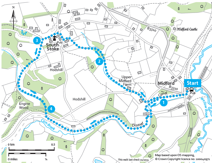
South Stoke circular (Bathscape Walk 14)

A pub-to-pub walk in the beautiful countryside south of Bath.

Distance

3.5 miles / 5.63 km

Duration

2 to 2.5 hours

Difficulty

May be steep slopes, moderate fitness

Shape

Circular

Route description

Start with an undulating climb up to the quintessential village of South Stoke before heading down to follow the route of the Somersetshire Coal Canal back to the start.

Start

Address

Hope and Anchor, Midford, Bath BA2 7DD, UK
View start on Google Maps

OS Grid Ref

ST760606

What3Words

miss.legs.points

Refreshments

The Hope & Anchor Pub at Midford, The Packhorse in South Stoke

Travel Info

Visit travelinesw.com. Bus stops on Midford Road, outside the Hope and Anchor and in South Stoke. Patrons only car parking behind the Hope and Anchor.

Navigation

Standing with your back to the Hope and Anchor, carefully cross the busy road. In front of you, you should see a footpath sign posted from the road and down a short flight of steps.

Follow this path, under the brick and steel former railway bridges. Go through a wooden gate and continue along the raised path beside the disused Somersetshire Coal Canal.

Just before a pipe mounted on red brick stands crosses the canal, the path forks 1. Take the right fork to cross the old canal ditch and follow a path slightly uphill until you meet a stile. Take care crossing the stile as on the other side you are straight on the road.

Turn left onto the minor road and walk past Upper Midford Farm and several other dwellings until you see a footpath sign on your right, ignore the arrow pointing right that goes up the steep grassy hill.

Pass through a wooden gate and cross the bottom of the field beyond to
another wooden gate. Go through this and onto a path, uphill again through a meadow (which is full of wild flowers in the spring and summer) between the trees, to another wooden gate 2. Go through and follow the tree lined path uphill to a wooden gate. Then follow the fenced path round the edge of the field and uphill until it widens out into a track. Follow the track around to the left ignoring the footpaths on the right, be sure to turn to enjoy the views here, before continuing on along a minor road passing Ivy Cottages. At the T junction turn right onto another minor road (Old School Hill) and follow it uphill passing the village hall and the Packhorse Pub.

The Packhorse is over 400 years old, and much research has gone into trying to establish when it was built, with the general consensus being it was before 1674, which is the date originally assumed as it is carved in the stone above the door. In 2018 it was opened as a community pub after locals rallied to save it from development into offices. So, a stop off here can be fully guilt free!

Continue uphill and follow the road as it curves round to the left. As the road levels out, the road forks. Continue along the level road and then take the right fork beyond a wooden field gate, with a pedestrian gate next to it. Follow the track along until it meets a fork 3. To continue the walk right away take the left fork downhill on a concrete track. Alternatively continue straight for a few metres to find a bench to take in the view.

When you are ready, pick up the route downhill and look out for Circuit of Bath way markers. You can follow these all the way back to the start, or continue to use these instructions.

Pass through the metal gateway (squeeze stile) to cross the field beyond,
heading to the bottom left corner. Stay on the path as it runs parallel to the track for a short while and then pass through another squeeze stile onto a woodland path. Continue downhill passing a spring on your right and then an attractive stone house on your left.

Go through a wooden gate into a field. Follow the path diagonally left across the field and down into the woodland below. Continue straight on by a tall post with lots of footpath signs on it. The post will be on your left and a stream on your right as you continue downhill albeit on a gentler slope.

The path will meet a metal field gate with a wooden pedestrian gate next to it. Go through the wooden gate and continue straight ahead. On your right you will see the ditch of the Somersetshire Coal Canal you were walking alongside at the very beginning of the walk.

Soon you should be able to see the stonework of what remains of a lock system which raised the canal level 135ft (41m) at this point. This point was known as The Bull’s Nose and it is the sharpest canal bend in the country. The 22 locks were opened in 1805 and allowed coal to be transported from the North Somerset Coalfield to Bath and Wiltshire more cheaply than by horse and cart.

Continue along the path, parallel to the canal until you pass through a gateway and under a brick bridge, beyond which is a minor road. In the tunnel is an information board all about the lock flight and canal 4.

Cross the road to a wooden gate and path beyond, to the left of Bridge Farm. Follow the fenced path along the edge of a meadow where you should be able to detect the canal ditch down to your right, into a woodland and through a metal gate. Turn right and then almost immediately left through another metal gate and down to the field below. The canal ditch is now on your left.

Follow the slightly raised footpath, which was once the tow path, through the field, through another metal gate and through another field to a wooden gate. Go through, staying on the path under a viaduct of the Great Western Railway which has a fantastic sycamore tree growing below, and then dividing around it.

Follow the path as it curves round to the left, through another wooden gate and then past a stone bridge. This is the Upper Midford Accommodation Bridge and it carried the road from Combe Down to Twinhoe across the canal before the Somerset and Dorset Railway provided an alternative
route next to their viaduct in Midford.

The path continues to curve round to the right to meet a wooden gate with the Midford aqueduct on your right. This is where the Radstock branch of the canal joined. Pass through the gate, taking care if you have dogs as horses often graze here. Stay on the path all the way back to the start.