Sudeley, Kenelm and Monk’s Hole (Cotswold Gateway Winchcombe Walk 3) - Circular Walk

Sudeley, Kenelm and Monk’s Hole. A gradual climb up to the ancient Salt Way before returning via the Gloucestershire Way with lovely views to the west.

Distance

5 miles / 8.05 km

Duration

2 to 2.75 hours

Difficulty

Uneven, steep slopes, good fitness

Shape

Circular

Route description

This route has been delivered in partnership with Winchcombe Welcomes Walkers www.winchcombewelcomeswalkers.com

Start

Address

Back Lane Car Park
View start on Google Maps

OS Grid Ref

SP025285

What3Words

surprise.insist.automatic

Public toilets

Back Lane car park near the library.

Refreshments

Pubs and cafes in Winchcombe.

Travel Info

Back Lane car-park (charges apply).

Navigation

Leave Back Lane car park via the far corner access into Cowl Lane. Turn right and follow the road to the High Street.

Turn right and after approx 60 metres turn left into Vineyard Street. Cross the River Isbourne, head up the slope and where the road bends to the right, keep straight ahead to enter the grounds of Sudeley Castle, passing the castellated Almsbury Lodge on your left.

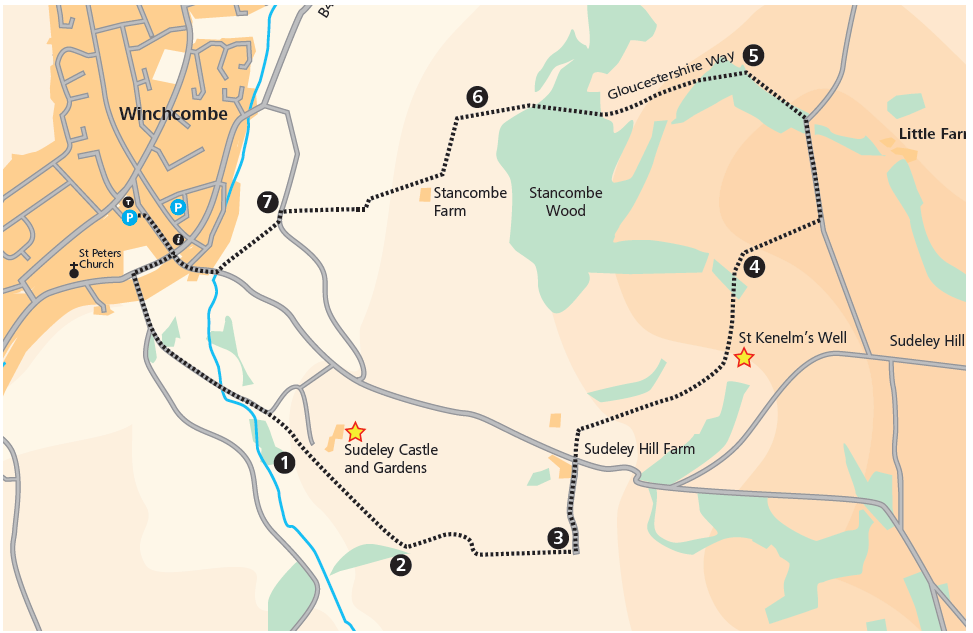
Follow the main driveway, crossing the lake by the bridge and continue gently uphill to meet a gate on your right (1). Go through, keeping the play area/fort on your left, and head for a metal gate beside a field gate entering the next field.

Go through the gate and continue ahead keeping to the path to the left. Follow the path to the far left corner of the field and a ramp/gate. (The Home Parks). Go through the gate and turn left (2). In 20 metres pass through another gate and walk ahead with trees and a farm track to your left.

In 200 metres follow the field boundary to the right and after a further 200 metres turn left over a footbridge and through a gate to walk gently uphill towards a house.

At the top, in front of the house, (3) turn left onto a lane. Follow the lane to a T-junction and carefully cross the road and turn left a short distance to meet a track leading to Sudeley Hill Farm. Here, opposite the Farm Shop sign, turn sharp right through a gate and walk up the field to a gate. Go through and continue ahead and meet a track; bear left on to the track, go through a gate and pass the stone building housing St Kenelm’s Well on your right.

Continue ahead and go through a gate beside a field gate, head uphill towards a gate on the horizon, to the right of woodland and a pig pen. When you reach the gate go through into the next field via a gate (4). Enter the next field and continue along the track ahead. The countryside changes from pasture land to open arable fields and the gradient levels out.

Follow the track, keeping the dry stone wall on your right until you reach a lane (Salt Way). Turn left following the Winchcombe Way sign and follow the lane downhill to Little Farmcote Farm. Bear left on the gated lane (if you are lucky you might have a view of the Stanway fountain ahead) and 25 metres after the gate on the left is a path by a field gate. Turn left through the gate and you will follow the Gloucestershire Way back to Winchcombe.

Cross the field to the gate, go through into the next field and cross the next field to another gate, with glorious views looking towards Toddington, the Malverns and Winchcombe railway station below.

Continue ahead and go through a field gate, (5) before turning left up a short steep slope to a stile. Cross the stile and continue a short way to a gate on the edge of the wood. Follow the path through the trees before you start to descend down to another gate.

Go through the gate to leave the scrubby area and follow the right hand field boundary to the far side of this long field, looking for a gate on your right. Go through the gate and turn left, following the path down to some trees, with fine views of the Malvern Hills from here.

Continue down through the trees, taking great care, as the path can be slippery in places.

At the bottom of the slope bear left and join a track which leads to a field gate, near a radio mast. Before you reach the gate, as the track turns left, (6) fork right down to a gate in some trees. Go through the gate and follow the path to another gate, and across a paddock to meet a gate by a lane.

Turn right onto the lane and then immediate left through a gate into a field, crossing it to the far side to a large sign ‘PATH’. Go through the gate and turn right towards another large sign ‘PATH’. Head to the left of the farm buildings to leave the field via a gate slightly hidden from view.

Go through the gate and take care as you emerge onto the lane, (Rushley Lane) (7). Turn left along the lane to shortly meet a gate on your right, signposted Gloucestershire Way. Go through the gate and cross the field (ridge and furrow) diagonally to the left towards some houses in the distance. Head for a gate on the surfaced path by some buildings. Go through the gate, along the path between properties to emerge in Castle Street.

Turn right here and follow the road up to the top, where it meets the High Street. To return to the car park turn left and shortly cross the road to enter Cowl Lane leading to the car park.