Winchcombe's 'Ultimate' Walk on Wheels circular

An ambitious 8 mile route designed for those using all-terrain mobility scooters. The route offers extensive views over the glorious Cotswolds landscape around the Sudeley valley.

Distance

8.5 miles / 13.68 km

Duration

3.5 to 4 hours

Difficulty

May be steep slopes, moderate fitness

Mobility aid rating

Stile free

Shape

Circular

Route description

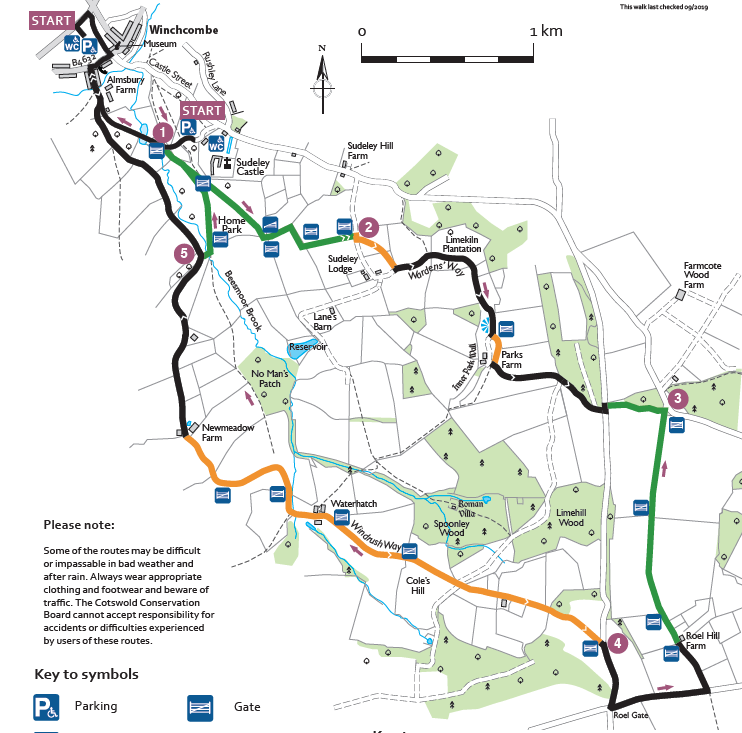
There are two starting points. The longer walk of 8.5 miles (13.7km) starts in Back Lane car park, Winchcombe off Back Lane which has accessible toilets. The alternative starting point of 7 miles (11.3km) is at Sudeley Castle car park with entrances off Vineyard Street and Sudeley Hill Road. Facilities are subject to the opening and closing times of Sudeley Castle. The route is on grass, field edges, stone and tarmac with long slopes to and from the Salt Way.

Start

Address

Back Lane Car Park
View start on Google Maps

OS Grid Ref

SP024286

What3Words

snowstorm.eased.closets

Public toilets

Disabled public toilets in Back Lane car park, Winchcombe. Toilets at Sudeley Castle Visitor Centre during opening times. For opening times visit: www.sudeleycastle.co.uk

Refreshments

Food Fanatics Delicatessen and the Corner Cupboard in Winchcombe. Cafe at Sudeley Castle during opening times. For opening times visit: www.sudeleycastle.co.uk

Travel Info

Back Lane car park, Winchcombe. (GL54 5PZ)

Navigation

Leave Back Lane car park via the entrance, turn right along the pavement for approx 20m and turn right again along the alley left of the library to join Cowl Lane. Turn right and follow the road to the High Street.

Cross the road towards the Methodist Church; turn right to follow the narrow pavement past Abbey Terrace and turn right down Vineyard Street. Cross a bridge and continue up a short incline towards the entrance to the Sudeley Castle. Follow the drive slightly downhill for approx. 500m, continue up an incline turning right through a field gate where driveway levels out. 1

(If using Sudeley Castle car park as a Start/Finish point, follow the road out of the car park in a westerly direction, ignoring the traffic no-entry sign. After approx 50m, reach the field gate on your left.)

Follow the Wardens’ Way across the Sudeley Castle Home Park. In approx 800m reach a ramped boardwalk and go though a ‘radar’ gate. Disabled ramblers will find a spliced rope attached to the gate to facilitate passage. Turn left and go approx 10 metres to another ‘radar’ gate.

Go through and follow the field edge for approx. 200m; turn right at the corner and follow the path. After 200m turn left across a bridge before going through a field gate and proceed up a gentle incline towards another gate at the top of the field. 2 Turn right for a few metres before turning left up the gravelled track. Continue for approx 2 kms along the Wardens’ Way on a mix of tarmac estate road and firm gravel track.

This part of the route is generally uphill, with some flat and slight downhill sections. None of the inclines are severe.

At the top of the escarpment you reach a road (Salt Way), turn left along the road for approx 50m, (cars tend to be driving quickly) before turning right along the Wardens’ Way. After approx 400m you reach a junction of paths near Deadmanbury Gate. 3 Here leave the Wardens’ Way and turn right along a bridleway. Follow the bridleway for approx 1.75 kms, passing through field gates and through Roel Hill Farm to reach a road. Turn right slightly uphill along the road following the Windrush Way. After approx 500m reach the road junction at Roel Gate.

Turn right and follow the road for approx 400m before you turn left through a field gate towards Spoonley Farm. 4 The tarmac road continues on a gentle slope down Coles Hill for almost approx. 1.8 kms to the barns and outbuildings of the former Waterhatch Farm.

After Waterhatch, the track continues slightly downhill before the track bends sharply to the right, it then rises gently for approx 300m. At this point, the Windrush Way continuing ahead across a field, but the route turns left, continue to follow the track. After 750m you reach Newmeadow Farm, continue along the Old Brockhampton Road (the road is a dead-end, so there is generally very little traffic).

In a little over 1 kilometre the road reaches a track on the right. 5 (At this point, if you are returning to Sudeley Castle car park, take this track, cross a bridge and rejoin the Windrush Way before turning left through a field gate into Sudeley Home Park. Follow the path towards the castle, go through a gate and, keep the adventure playground fence on your right, continue to the field gate by a driveway. 1 Turn right and re-enter the Sudeley Castle car park).

If you are returning to Back Lane car park continue along the road for 1.2 kilometres to again reach the entrance to Sudeley Castle. Retrace your route to the start of the shops and return to the car park.

Route media